
Indian Rivers and Drainage System
Introduction
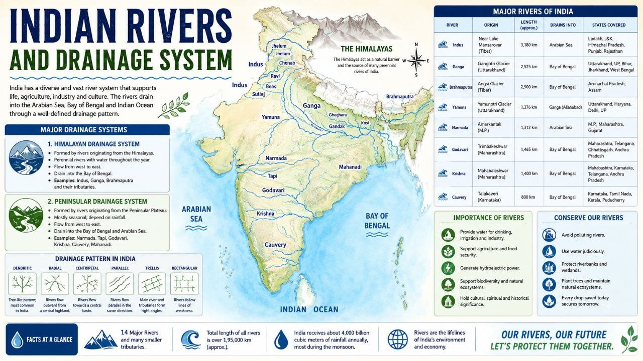
Rivers are the lifeline of India. They provide water for drinking, irrigation, industries, transportation, and hydroelectric power generation. India’s river system is one of the most extensive in the world and plays a vital role in the country’s economy, agriculture, and ecology.
The drainage system of India refers to the network of rivers and their tributaries that drain water from different parts of the country into seas, oceans, or inland basins.
What is a Drainage System?
A drainage system is a pattern formed by rivers, streams, and their tributaries that collect and carry water from an area into a larger water body such as an ocean, sea, or lake.
The drainage pattern depends upon:
- Relief and topography
- Geological structure
- Climate
- Slope of the land
Classification of Indian Rivers
Indian rivers can be broadly classified into:
1. Himalayan Rivers
These rivers originate from the Himalayan glaciers and receive water throughout the year.
Characteristics
- Perennial (flow throughout the year)
- Large drainage basins
- Extensive tributary systems
- Form large floodplains and deltas
Major Himalayan Rivers
1. Indus River System
- Origin: Near Lake Mansarovar, Tibet
- Length: About 3,180 km
- Flows through: Tibet, India, Pakistan
- Tributaries:
- Jhelum
- Chenab
- Ravi
- Beas
- Sutlej
2. Ganga River System
- Origin: Gangotri Glacier (Bhagirathi River)
- Bhagirathi and Alaknanda meet at Devprayag to form Ganga.
- Length: About 2,525 km
Major Tributaries:
- Yamuna
- Ghaghara
- Gandak
- Kosi
- Son
Importance:
- Supports the largest population in India.
- Considered the holiest river by Hindus.
3. Brahmaputra River System
- Origin: Angsi Glacier in Tibet
- Known as Tsangpo in Tibet
- Enters India through Arunachal Pradesh
- Known as Brahmaputra in Assam
Major Tributaries:
- Dibang
- Lohit
- Subansiri
- Manas
2. Peninsular Rivers
These rivers originate from the Peninsular Plateau.
Characteristics
- Seasonal rivers
- Depend mainly on rainfall
- Shorter length
- Smaller drainage basins
East-Flowing Rivers
These rivers flow into the Bay of Bengal.
Mahanadi
- Origin: Chhattisgarh
- Length: 858 km
Godavari
- Origin: Trimbakeshwar, Maharashtra
- Length: 1,465 km
- Longest Peninsular River
- Known as “Dakshin Ganga”
Krishna
- Origin: Mahabaleshwar, Maharashtra
- Length: 1,400 km
Kaveri (Cauvery)
- Origin: Talakaveri, Karnataka
- Length: 800 km
West-Flowing Rivers
These rivers flow into the Arabian Sea.
Narmada
- Origin: Amarkantak Plateau
- Flows through a rift valley
- Forms an estuary
Tapi (Tapti)
- Origin: Satpura Range
- Parallel to Narmada
Sabarmati
- Origin: Aravalli Hills
Mahi
- Origin: Madhya Pradesh
Drainage Patterns in India
1. Dendritic Pattern
- Tree-like branching structure
- Most common pattern
Examples:
- Ganga Basin
- Godavari Basin
2. Trellis Pattern
- Tributaries join main river at right angles
Examples:
- Folded mountain regions
3. Radial Pattern
- Rivers flow outward from a central peak
Examples:
- Amarkantak Plateau
4. Rectangular Pattern
- Developed due to faulting and jointing
Examples:
- Vindhyan Region
5. Centripetal Pattern
- Rivers flow towards a central depression
Examples:
- Inland drainage regions
Inland Drainage System
Some rivers do not reach the sea and disappear into deserts or lakes.
Examples:
- Luni River
- Ghaggar River
These rivers are mainly found in:
- Rajasthan
- Haryana
Major River Valleys of India
| River | Major States |
|---|---|
| Ganga | Uttarakhand, UP, Bihar, West Bengal |
| Yamuna | Uttarakhand, Haryana, Delhi, UP |
| Godavari | Maharashtra, Telangana, Andhra Pradesh |
| Krishna | Maharashtra, Karnataka, Andhra Pradesh |
| Narmada | Madhya Pradesh, Gujarat |
| Brahmaputra | Arunachal Pradesh, Assam |
Importance of Rivers
Agriculture
- Irrigation of crops
- Fertile alluvial soil
Drinking Water
- Main source of freshwater
Hydroelectric Power
- Generation of electricity
Transportation
- Inland waterways
Fisheries
- Source of livelihood
Tourism
- River cruises
- Religious tourism
River Water Disputes in India
Some important river disputes include:
- Cauvery Water Dispute
- Krishna Water Dispute
- Ravi-Beas Water Dispute
- Mahadayi Water Dispute
Important Facts for Competitive Exams
One-Liner Facts
- Longest river in India: Ganga
- Longest river entirely in India: Godavari
- Largest river basin: Ganga Basin
- Longest Peninsular River: Godavari
- River known as Dakshin Ganga: Godavari
- River known as Bihar’s Sorrow: Kosi
- River known as Bengal’s Sorrow: Damodar
- River known as Lifeline of Assam: Brahmaputra
- Narmada flows into: Arabian Sea
- Ganga flows into: Bay of Bengal
Frequently Asked Questions (FAQs)
Which is the longest river in India?
The Ganga is the longest river flowing through India.
Which is the longest river entirely within India?
Godavari River.
Which river is called Dakshin Ganga?
Godavari River.
Which rivers form the Indus River System?
Indus, Jhelum, Chenab, Ravi, Beas, and Sutlej.
What are the two major river systems of India?
Himalayan Rivers and Peninsular Rivers.
Conclusion
India’s rivers and drainage system are essential for agriculture, industry, transportation, and ecological balance. Understanding river systems is crucial for competitive examinations such as UPSC, SSC, Railway, UPPSC, UP Police, RO/ARO, and other state-level exams. Knowledge of river origins, tributaries, drainage patterns, and river basins helps candidates score well in Geography and General Studies sections.
Practice more Geography MCQs and Mock Tests regularly to strengthen your exam preparation.
Leave a Reply